

Akshay Deoras
Severe Weather Forecaster
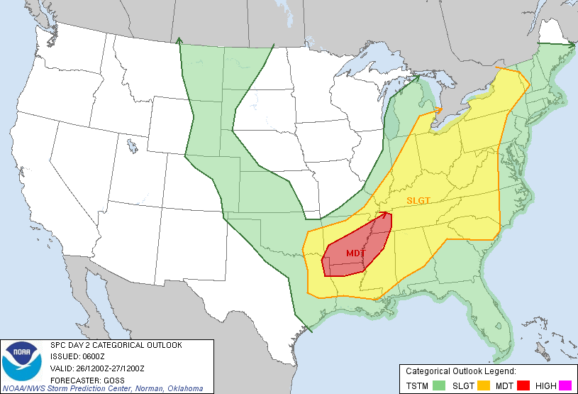
There is a Moderate Risk of Severe Storms across Much of Arkansas and some areas in MO on Monday
The mid level shortwave trough currently digging in from pacific is expected to bring severe weather into the plains Monday as the embeded jet streaks at the nose of upper level jet
Favored by the eastward progression of the dryline and the SFC low in Western to Central Oklahoma, severe storms shall fire around Central OK in the perfectly unstable warm sector where CAPE values are over 2000J/Kg and LI over -7
Moisture shall not be a problem from this setup as SFC dewpoints are over 60F indicating nice moisture
As the storms brace eastwards into SW Ok and Western Arkansas, presence of a good wind shear shall support developments of supercells capable of producing large hails and few tornadoes.
Hodographs indicate less curvatures across SW Oklahoma so I w'd probably not think of this location for tornadoes
As the Low level jets intensity over 50kt in Arkansas and favored by steep lapse rate in evening hours, Threat for Tornadoes builds up.
What it seems right now, areas situated West and NW of Little Rock shall get to see some tornadoes at night time especially around Hot Spring,AR
People must watch out for this region.
Tue
No comments:
Post a Comment