Showing posts with label MODERATE RISK IN USA. TORNADOES POSSIBLE. Show all posts

Sunday, April 24, 2011

Round of Severe Weather on Monday,Tuesday,Wednesday


METD WEATHER
Akshay Deoras
Severe Weather Forecaster

There is a Moderate Risk of Severe Storms across Much of Arkansas and some areas in MO on Monday
    
The mid level shortwave trough currently digging in from pacific is expected to bring severe weather into the plains Monday as the embeded jet streaks at the nose of upper level jet
Favored by the eastward progression of the dryline and the SFC low in Western to Central Oklahoma, severe storms shall fire around Central OK in the perfectly unstable warm sector where CAPE values are over 2000J/Kg and LI over -7

Moisture shall not be a problem from this setup as SFC dewpoints are over 60F indicating nice moisture

As the storms brace eastwards into SW Ok and Western Arkansas, presence of a good wind shear shall support developments of supercells capable of producing large hails and few tornadoes.
Hodographs indicate less curvatures across SW Oklahoma so I w'd probably not think of this location for tornadoes

As the Low level jets intensity over 50kt in Arkansas and favored by steep lapse rate in evening hours, Threat for Tornadoes builds up.

What it seems right now, areas situated West and NW of Little Rock shall get to see some tornadoes at night time especially around Hot Spring,AR

People must watch out for this region.


Tue
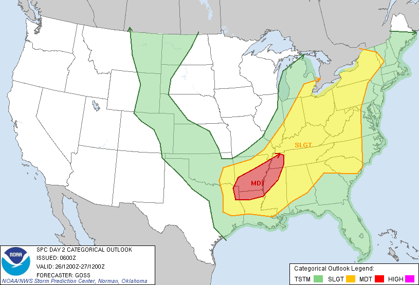
VALID 261200Z - 271200Z     
   ...THERE IS A MDT RISK OF SVR TSTMS ACROSS 
FAR NORTHEAST    TEXAS...SOUTHERN AND EASTERN
 ARKANSAS...WESTERN    TENNESSEE...NORTHWEST 
MISSISSIPPI...AND NORTHERN LOUISIANA...

As the trough digs in, round of severe weather can be expected into many areas


Wed- In Alabama and Georgia


Wednesday, February 23, 2011

Moderate Risk across Arkansas,NW MS,Tennessee on Thu

400TH POST ON THE BLOG!


METD WEATHER
Akshay Deoras
Severe Weather Forecaster

...THERE IS A MDT RISK OF SVR TSTMS OVER CNTRL AND ERN AR...NRN    MS...AND WRN TN...        ...THERE IS A SLGT RISK OF SVR TSTMS FROM ERN OK AND NERN TX EWD    INTO THE TN AND LOWER OH VALLEYS...

An upper level low stretching presently over West CA shall set into motion due to the Southerly Jet stream with portions of Jet Stream ( Jet Streak) amplifying over close to New Mexico by today afternoon.
With potent jet streaks of 120kt by tomorrow morning to afternoon across SW OK,NW TX along with the deepening of surface low from late periods of today, squall line thunderstorms are expected to move along the dryline close to the low pressure.

Thunderstorms with rainfall,gusty winds and hails likely to move across Eastern OK,NE TX into Arkansas.

A quickly developing Low level Jet having Southerly flow shall rapidly bring moisture into Arkansas,Louisiana,Mississippi,Alabama,Tennessee reaching upto 40kt afternoon on Thursday and amplifying into 50-60kt by late evening period.
With little but sufficient MLCAPE for convection and plenty of low level wind shears in the warm sector with dewpoints of 70F, Thunderstorms shall modify to strong thunderstorms with some of them as supercells.

On Thursday ( Morning till afternoon)
Thunderstorms shall be capable of producing hails and winds across Central,Eastern,South Eastern OK,NE TX and NRN TX.

By Mid Afternoon - Late Afternoon
With developing LLJ and rich shear environment in the Unstable conditions over Arkansas,Western Mississippi
Ongoing thunderstorms shall modify to isolated supercells by late evening capable of hails and winds

With the best feature of 60kt LLJ at very late periods on thursday into friday morning,
Tornadoes are possible in area from Central to NE Arkansas, NW corridor of Mississippi,Tennessee BY LATE NIGHT TO EARLY MORNING HOURS ON FRIDAY
** NOCTURNAL TORNADOES ARE VERY DANGEROUS.

THE POSITION OF STORMS WILL BE DECIDED BY THE WARM FRONT SO POSITION MIGHT CHANGE AS PER THE NEW MODEL RUNS

MY TORNADO TARGET LIES ENE of Jackson,TN