METD WEATHER
Akshay Deoras
Severe Weather Forecaster
MAJOR DUST-STORM HITS SAUDI CITIES,KUWAIT CITY,OMAN AND OTHER GULF COUNTRIES
Though the Dust-Storms are common in the Gulf States, a major dust-storm hit parts of Saudi Arabia,Kuwait,Oman,Gulf Countries like UAE and Yemen. Flight delays have been reported in Yemen.
Poor visibility conditions are being reported from UAE,Oman. In Sindh area also poor visibility and widespread dust is being reported.
Below are the photos of today afternoon from Muscat sent by METD WEATHER's Fan Mon Soon.
One can clearly see the dust in the two images.


More photos from UAE can be seen here-
The necessary conditions (discussed below) came together which triggered a dust storm. The passage of cold front across Saudi Arabia, Oman has caused the temperatures to come down significantly.

The 1430z satellite imagery clearly shows dust feature in Saudi Arabia and South-West of it. Flaring convection is seen at the lower left of the image indicating some presence of a low pressure area
WARNING AND FORECAST:
* THE TYPICAL PERIOD OF A SHAMAL SANDSTORM IS 3-5 DAYS. * HOWEVER CONDITIONS ARE NOW DECREASING FOR ANOTHER MAJOR ONE
*HOWEVER PEOPLE ARE REQUESTED TO FOLLOW THE LOCAL WEATHER AND GOVERNMENT OFFICIALS.
*THE ROYAL OMAN POLICE HAS WARNED PEOPLE OF OMAN TO TAKE PRECAUTIONS TILL THIS WEDNESDAY
What are such dust-storms???
Dust-storms often referred as Sandstorms are a natural phenomena occurring in the arid,desert regions where there are persisting conditions for synoptic lifting of sand i.e having a significant source of sand in the vicinity. The primary condition required for a sandstorm is the presence of a large area of sand. An image posted below shows the Dust source areas which are widely observed in Iraq.


Courtesy- Air Force Weather Agency/NRL,USGC and COMET education programe.
The Next prominent thing required depends on the type of the dust-storm. There are two types
1) The Haboob
2) Shamal type
We shall not consider much details about the Haboob type as the recent sand-storm is of the Shamal Type.In the Haboob type, the outflow of a thunderstorm is responsible for triggering the sand-storm.
The thunderstorms have an outflow boundary and hence an ouflow where the winds are moving out of the system as the thunderstorms move. The gust front or the leading edge of air of a thunderstorm then carries dust with it. In a similar way, downbursts also trigger the storms. Downburst happens when the downdraft (coloumn of air coming down from thunderstorm) appears suddenly.

Example of Haboob-
The another type is Shamal type of a dust storm!
In a Shamal type, the dust storm is created due to a perfect combination of air pressures and air fronts.
In a Shamal type, an airfront (mostly cold front) where a cold front is a leading edge of a cool air mass carries dust with it.
What is a Shamal??
Its a local name given to the North-Westerly winds blowing at lower levels of the atmosphere over areas like Iraq,Saudi Arabia,Kuwait etc. As a North-Westerly wind setup is responsible for this type of dust-storm, its named as Shamal dust storm.
Mechanism-
We shall now see how a Shamal type of dust storm or pre-frontal dust storm is set up!
The most important ingredient required is a Low Pressure area over Iran or vicinity. Low pressure area forms when the air in the region rises up in the atmosphere reducing the overall air density and hence pressure in the region. Occasional low pressures form in the areas like Iran at the 500mb or mid atmosphere level.
As seen from the below map, the areas north of Syria etc have higher elevation. When the Shamal winds blow, they carry cool air from that region towards warmer region or warmer air of areas like Saudi Arabia etc. Thus the leading edge of this air mass is what we call as the cold front denoted by the black line with triangles over Oman region . Since the below region shows the Shamal sandstorm at an age of 3-4 days i.e 3-4 days after its birth.
In the below image, just below L 500mb in Iran you can see white dashed lines. The white dashed lines are called as troughs which are nothing but imaginary lines which can be drawn which connects low pressure regions. This trough feature is easily noted in the upper level maps

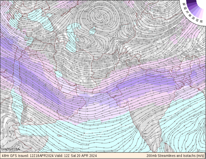
Above- IMG 2
The upper atmospheric map shows the trough feature over Iran. Its an amplified trough (shown by a bit purple region)
Image Courtesy-
THE COMET PROGRAME

There is also a jet stream factor (jetstreams are the currents of air at higher altitude of over 30,000 ft which are flowing throughout the world from west to east direction ). Whenever a polar jet stream digs more southward near Iraq or Syria area it comes much closer to the subtropical jet stream which presence is shown in the upper atmospheric map i.e IMG 2. Due to this, there is a interaction between the two jets which amplify a part of the cold front as seen below

In the above image, the blue line is a cold front heading in the direction where the triangle is pointing, it can be seen that the surface max winds are amplified and hence much more sand can be lifted in such a case. Also due to this arrangement lifting of sand is enhanced.
Thus all the conditions are together for a perfect shamal sandstorm.
Associated dust area-
Depending on the cold front movement, the dust area is divided into two parts-
Pre-frontal area and post frontal area.
A pre-frontal area is that area from where the cold front is yet to pass and post frontal is that area over which the cold front has already passed.

Here,
the red lines are warm front which is opposite to the blue cold front!
What to do during a dust-storm
Check this link
http://www.wikihow.com/Survive-a-Dust-Storm-or-Sandstorm
Akshay Deoras
Severe Weather Forecaster
MAJOR DUST-STORM HITS SAUDI CITIES,KUWAIT CITY,OMAN AND OTHER GULF COUNTRIES
Though the Dust-Storms are common in the Gulf States, a major dust-storm hit parts of Saudi Arabia,Kuwait,Oman,Gulf Countries like UAE and Yemen. Flight delays have been reported in Yemen.
Poor visibility conditions are being reported from UAE,Oman. In Sindh area also poor visibility and widespread dust is being reported.
Below are the photos of today afternoon from Muscat sent by METD WEATHER's Fan Mon Soon.
One can clearly see the dust in the two images.


More photos from UAE can be seen here-
The necessary conditions (discussed below) came together which triggered a dust storm. The passage of cold front across Saudi Arabia, Oman has caused the temperatures to come down significantly.

The 1430z satellite imagery clearly shows dust feature in Saudi Arabia and South-West of it. Flaring convection is seen at the lower left of the image indicating some presence of a low pressure area
WARNING AND FORECAST:
* THE TYPICAL PERIOD OF A SHAMAL SANDSTORM IS 3-5 DAYS. * HOWEVER CONDITIONS ARE NOW DECREASING FOR ANOTHER MAJOR ONE
*HOWEVER PEOPLE ARE REQUESTED TO FOLLOW THE LOCAL WEATHER AND GOVERNMENT OFFICIALS.
*THE ROYAL OMAN POLICE HAS WARNED PEOPLE OF OMAN TO TAKE PRECAUTIONS TILL THIS WEDNESDAY
What are such dust-storms???
Dust-storms often referred as Sandstorms are a natural phenomena occurring in the arid,desert regions where there are persisting conditions for synoptic lifting of sand i.e having a significant source of sand in the vicinity. The primary condition required for a sandstorm is the presence of a large area of sand. An image posted below shows the Dust source areas which are widely observed in Iraq.

Below shows the Major Dust producing Regions where there is a significant region in Iraq,Saudi Arabia

The Next prominent thing required depends on the type of the dust-storm. There are two types
1) The Haboob
2) Shamal type
We shall not consider much details about the Haboob type as the recent sand-storm is of the Shamal Type.In the Haboob type, the outflow of a thunderstorm is responsible for triggering the sand-storm.
The thunderstorms have an outflow boundary and hence an ouflow where the winds are moving out of the system as the thunderstorms move. The gust front or the leading edge of air of a thunderstorm then carries dust with it. In a similar way, downbursts also trigger the storms. Downburst happens when the downdraft (coloumn of air coming down from thunderstorm) appears suddenly.
Example of Haboob-
The another type is Shamal type of a dust storm!
In a Shamal type, the dust storm is created due to a perfect combination of air pressures and air fronts.
In a Shamal type, an airfront (mostly cold front) where a cold front is a leading edge of a cool air mass carries dust with it.
What is a Shamal??
Its a local name given to the North-Westerly winds blowing at lower levels of the atmosphere over areas like Iraq,Saudi Arabia,Kuwait etc. As a North-Westerly wind setup is responsible for this type of dust-storm, its named as Shamal dust storm.
Mechanism-
We shall now see how a Shamal type of dust storm or pre-frontal dust storm is set up!
The most important ingredient required is a Low Pressure area over Iran or vicinity. Low pressure area forms when the air in the region rises up in the atmosphere reducing the overall air density and hence pressure in the region. Occasional low pressures form in the areas like Iran at the 500mb or mid atmosphere level.
As seen from the below map, the areas north of Syria etc have higher elevation. When the Shamal winds blow, they carry cool air from that region towards warmer region or warmer air of areas like Saudi Arabia etc. Thus the leading edge of this air mass is what we call as the cold front denoted by the black line with triangles over Oman region . Since the below region shows the Shamal sandstorm at an age of 3-4 days i.e 3-4 days after its birth.
In the below image, just below L 500mb in Iran you can see white dashed lines. The white dashed lines are called as troughs which are nothing but imaginary lines which can be drawn which connects low pressure regions. This trough feature is easily noted in the upper level maps
Above- IMG 2
The upper atmospheric map shows the trough feature over Iran. Its an amplified trough (shown by a bit purple region)
Image Courtesy-
THE COMET PROGRAME
There is also a jet stream factor (jetstreams are the currents of air at higher altitude of over 30,000 ft which are flowing throughout the world from west to east direction ). Whenever a polar jet stream digs more southward near Iraq or Syria area it comes much closer to the subtropical jet stream which presence is shown in the upper atmospheric map i.e IMG 2. Due to this, there is a interaction between the two jets which amplify a part of the cold front as seen below
In the above image, the blue line is a cold front heading in the direction where the triangle is pointing, it can be seen that the surface max winds are amplified and hence much more sand can be lifted in such a case. Also due to this arrangement lifting of sand is enhanced.
Thus all the conditions are together for a perfect shamal sandstorm.
Associated dust area-
Depending on the cold front movement, the dust area is divided into two parts-
Pre-frontal area and post frontal area.
A pre-frontal area is that area from where the cold front is yet to pass and post frontal is that area over which the cold front has already passed.
Here,
the red lines are warm front which is opposite to the blue cold front!
What to do during a dust-storm
Check this link
http://www.wikihow.com/Survive-a-Dust-Storm-or-Sandstorm
Hi I'm Tyrone from Karachi. Here it is still a bit dusty but not as dusty and hazy as yesterday evening / night when it was terrible and low visibility.
ReplyDeleteP.S. I regularly update on weather condition on Rajesh's blog as and when anything unusual happens
Hi Tyrone, I know about you
ReplyDelete