Wednesday, May 12, 2010

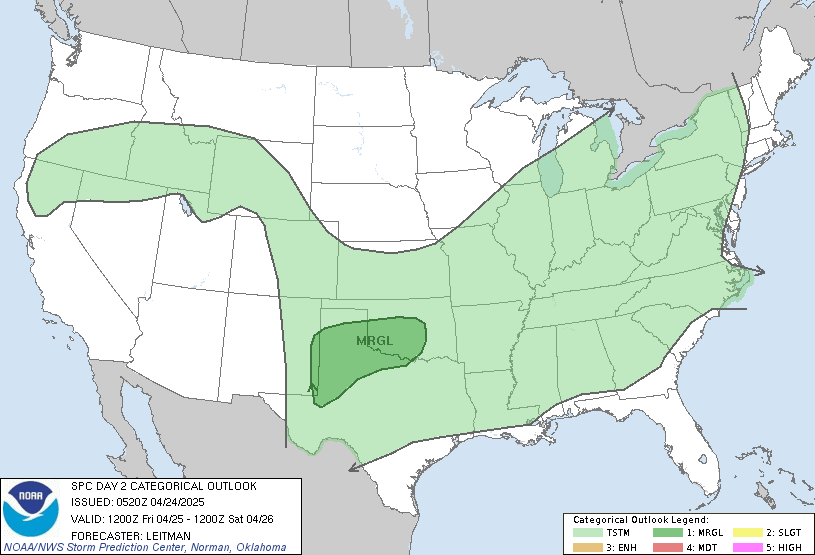
SLIGHT RISK in Southern Plains and Mid atlantic region


METD WEATHER,
Akshay Deoras
Extreme Weather Forecaster,

The stagnant trough will cause another round of storms in USA after causing 37 tornadoes on 10th May.
Along with the surface low, LLJ will eject across the warm sector backed with an approaching cold front by late afternoon to evening. The atmosphere will mostly remained CAPPED till late afternoon inhibiting convection. Classic 45kt LLJ will rapidly transport moisture if the surface winds remained away from Kansas area. Severe convection will happen into evening hours amidst a strong CAPE of 4000J/Kg leading to extreme updrafts and supportive to Very Large hails due to cool air aloft. But there is some problem with shears. The shears are not that strong for causing Severe tornadoes but 200 m2 s2 for some will rotate supercells. The HP cells are likely. The SKEW T is depicting a Low LCL and a 1.28PW right now.
By evening there will be a little cap which can be a cause of concern as it may reduce the severity of storms. Though this event can be good for tornadoes especially in Eastern Kansas than Oklahoma. SPC is getting a 10% for Tornadoes across Extreme Northern Ok,Eastern KS,NW MO
I expect tornadoes SE KS in the vicinity of cold front. The cold front will be the KEY for tornadoes

WEATHER ALARM FOR NAGPUR

METD WEATHER,
AKSHAY DEORAS
Extreme Weather Forecaster,

CONCERNING- VERY HOT WEEK IN NAGPUR

IMMEDIATE ACTION REQUESTED

This week seems to make a record with reference to temperature in
Nagpur. As was being expected by me, This years maximum touched 46.3C
today<12th May>.
The coming week is going to be hot due to no cloud cover, no strong
cool air pumping from north, no rain.
METD WEATHER,INDIA IS ISSUING A SPECIAL WEATHER ALERT FROM 10AM,13TH
MAY 2010 TO 20TH MAY 2010.
EVERYDAY;S TEMP WILL BE MORE THAN 45.5C AND AS HIGH NEAR 47C THOUGH I
AM NOT THAT CONFIDENT WITH 47C. STABLE TEMP OF 46 IS DUE FOR THE WEEK

PLEASE DONT TAKE ALL MY WORDS AND WARNINGS LIGHTLY. THIS HEAT IS
SEVERE AND CAN TAKE ANYONE'S LIFE. A NEW RECORD ALSO POSSIBLE

Monday, May 10, 2010

EXTREMELY DANGEROUS WEATHER SITUATION IN OK AND KS

METD WEATHER,
AKSHAY DEORAS
Extreme Weather Forecaster

Concerning- a HIGH RISK OF SEVERE WEATHER with Greatest tornado potentials

IMMEDIATE ACTION REQUESTED

All weather models and patterns in the RUC 16Z are suggesting some outrageous Tornadoes

A classic Cut off trough will spin nosing NE WDS over Central Kansas and Oklahoma causing a very active atmosphere for convection. The strong Low level jets will develop to 50kt transporting ample moist air mass into Oklahoma, Kansas and MO. 
By 8z, CAPE FOR CENTRAL Ok will be 6000J/Kg meaning supercells will release many tornadoes as they will be overloaded with CAPE. The supercells will rotate extremely due to 450 m2 s2 low level shears at 0-1km and excellent directional shears. The PW is above 1.0 meaning HP supercells with possibly DAMAGING HAILS AND EXTREMELY BAD LONG TRACK TORNADOES POSSIBLE. the EHI are rising to 10.0 in Central OK and extremely bad, 
THIS SITUATION CAN BE LIKE 1999 TORNADO OUTBREAK

I WILL WARN PEOPLE ALL OVER IN OKLAHOMA,EXCEPT SW OK... SE KS,NW MO,EXTREME EAST AR
I WILL PLAY INITIAL TARGET OF WICHITA,KS
MY SEVERE WEATHER RANGE IS FROM WICHITA,KS TO EXTREME SE OF OK
MY TORNADO RANGE IS TARGETED FOR CENTRAL OK TO WICHITA,KS
NIGHT TORNADOES ARE LIKELY AND RAIN WRAPPED. THEY ARE DANGEROUS

VALID 101630Z - 111200Z        ...THERE IS A HIGH RISK OF SVR TSTMS OVER PORTIONS OF SOUTH    CENTRAL/SOUTHEAST KS...AND CENTRAL/NORTHEAST OK THIS AFTERNOON AND    EVENING...        ...THERE IS A MDT RISK OF SVR TSTMS SURROUNDING THE HIGH RISK IN    KS...OK...SW MO...AND NW AR...        ...THERE IS A SLGT RISK OF SVR TSTMS FROM CENTRAL/NW TX TO THE    CENTRAL PLAINS AND MID MS VALLEY THROUGH TONIGHT...    

I will warn 

Saturday, May 8, 2010

Severe Weather to happen in Tornado Alley on Monday


METD WEATHER,
Akshay Deoras,
Extreme Weather Forecaster,

Concerning- MODERATE WEATHER RISK
THERE IS A MDT RISK OF SVR TSTMS ACROSS NCNTRL/NE OK...SCNTRL/SE
KS AND EXTREME SW MO...
THERE IS A SLGT RISK OF SVR TSTMS FROM THE CNTRL/SRN PLAINS TO    THE MID-MS VLY...

The 00z+48hr NAM range are indicating a classic trough digging in the southern plains. Setup at the 300mb indicates 90kt westerly flow with embeded SFC LOW PRESSURE OF 1000mb coupled by southerly winds of impressive 40kt at OK-Ks border and 50kt at OK-TX border at the lower levels. Much moisture for convection will be transported in the interior resulting 60F+ dewpoint.During the morning hours, A lot of CIN or Convective inhibition will be present over the tornado alley. a strong CIN over -200 will inhibit convection as the NAM indicates.
The morning setup indicates thunderstorm formation in Southern Oklahoma to Central TEXAS. The Lifted index values are -5. yet strong CAP at hold will inhibit convection if it doesn't bust away on Monday plots.
Much later, in afternoon to evening convection will start by firing some intense thunderstorm as CAP reduces and becomes borderline in the vicinity of warm front. A strong CAPE over 3000J/Kg will destabilise the environment and lead to intense updrafts and possibly severe hails when thunderstorms fire. The Lifted condensation level will be at 850mb and less leading to low cloud bases. Upper level CAPE will lead to strong convection and rotations in Oklahoma to Kansas as the low level shears are over 200 m2 s2 round the event with stronger SHEARS is Kansas.The moderate risk deals with the 60kt LLJ in MO-KS border
The EHI values are over 3.0 in the 0-1km range and solid of 6.0 in 0-3km range from Central Tx to central KS. The supercells will be a LP to HP in diff. areas
Tornado probability will be high in Oklahoma and Kansas border and Western Oklahoma for the borderline CAP.
If CAP BUSTS AWAY, This event will be HISTORIC for Severe Hails and weather in Oklahoma and Kansas. For now, I will be with Kansas

Thursday, May 6, 2010

A possible TORNADO DAY IN NORTHERN USA


METD WEATHER
Akshay Deoras
Extreme Weather Forecaster,

Concerning- SLIGHT RISK IN NRN USA

A unidirectional flow is moving EWDS across Northern STATES. By 12z, FRI Jets of 90kt aloft will flow across INDIANA,OHIO with a surface southerly LLJ of 40kt to pull the moisture from Southern Areas.A warm front at 12z in Indiana on Friday with a 1500-2000J/Kg cape and warm air near surface Cyclone will fire thunderstorms which will move NE towards OH with LI of -2 pretty low. CAPPING WIll not be a problem since air is pretty warm near SFC to mid levels. The main game will be late afternoon as the warm front digs in NEWDS and Storms race Eastwards. Moisture at OHIO and West PA will be good as being depicted by SKEW T with dewpoints to 60F at SFC. Also the supercells that can explode in OH-Indiana will be a LP supercells as PW is much high North in Michigan causing RAINS and possible hails during the event.
A lot of focus will be mainly in Eastern Indiana to NW PA as when CB clouds will build a LOW LCL will create them from 850mb. This is a sign of low cloud bases which can intensify and possibly turn to Meso. as SHEAR 0-1km are nice of 200m2 s2 with vertical veering winds. SPC focuses to 45% risk across OH,NE IN,NW PA with a likely 10% tornado risk and HIGH HAIL RISK with good SFC PRESSURE OF 1000mb.
Stay tuned for Updates, more possible SEVERE WEATHER days will kick off across SUN with the best turning on 10th May,MON.

Sunday, May 2, 2010

2010 INDIAN MONSOON TRACK

METD WEATHER,
AKSHAY DEORAS
Extreme Weather Forecaster,

2010 INDIAN MONSOON TRACK IS BEING RELEASED ON A STUDY OF PREVIOUS MONSOON RECORDS AND PRESENT NECESSARY CONDITIONS

Monsoon is a weather phenomena which forms a season in India. It is associated with rainfall conditions over most parts of India during June-September

CLIMATOLOGY
During summers most of areas of North India mainly Rajasthan,Thar Desert gets heated during summers. The warm air lifts up leaving down a surface low pressure. This low pressure develops over the land and high pressure over Arabian Sea. This causes warm moist air to move inwards towards land especially to upper Himalaya mountains. These mountains act as barrier and prevent the transportation of moisture towards north. This results in heavy rains over Central India

REQUIREMENTS
The most important requirement is a warm land caused due to extensive heating during summers
2010 has been a surprising year which actually is because the temperatures soared up in later March and April. Its 2 days in May but the temperatures are 3-7C BELOW NORMAL in most areas. This was due to a low pressure area over southern India which caused rains in many parts.
In my opinion, May will be WARM. The recent showers have disturbed the weather in NAGPUR.
Still the maximum temperatures are enough with a notable low pressure 1008mb. The Sea Surface Temp. over Arabian sea is 32C as recorded today.

METD WEATHER OUTLOOK
The 2010 MONSOON WILL BE ACTIVE IN NAGPUR IN __ JULY___ . I am expecting a handful of Tropical Cyclones Activity in MAY END. So far warm SST has been in Bay of bengal but a parameter termed as MJO or Madden Julian Oscialltion which is anomaly track of rainfalls which indicate chances of Cyclones is fair in APRIL. MJO in BAY OF BENGAL in APRIL 2009 was more than 1.5 this year it is less than 1.
this can be considered as It will be a SLOW and LATE start to Cyclones. WE have no cyclone of the year in bay. Destructive cyclones had hit a few years back in April- May
This is sure that cyclones will kick off in June with the first getting before June 15. This will disturb the Monsoon process. So I am expecting a kick off to monsoon in July.

METD TRACKS-
2010 MONSOON will be MORE ACTIVE IN AUG-SEPT. FOR JULY IT WILL BE DEFICIENT TO AS LARGE AS 50%. AS LAST YEAR IT RECOVERED, IT CAN THIS YEAR
BUT STILL ITS A NEG.track from my side

DATES-
MONSOON STRIKE IN MAHARASHTRA
NORMAL - 15TH JUNE.... 2010 - 1ST JULY***
KERELA - 1ST JUNE........ 2010- 15TH JUNE OR LATE
***-
LESS ACCURACY

Saturday, May 1, 2010

HIGH RISK FOR TORNADOES IN AR-MS-KY


METD WEATHER,
Akshay Deoras
Extreme Weather Forecaster,

Concerning- High risk for tornadoes in USA

A massive digging trough which is slowly progressing towards EAST is again going to set things worse today. FRI's risk was not so appreciatable esp for PDS in AR. 20 tornadoes were confirmed. ON SAT, strong lower level jets are expected to build during late afternoon in LA-AR-TN-KY area. This winds will transport moisture over southern states and will increase the dewpoints in LA-AR to more than 70F. Without CAPING, Convection is surely going to be intense amidst a strong more than 2000J/Kg CAPE over AR-LA and plenty good low level deep shears over 200m2 s2 to rotate storms. The main risk applies in areas in the vicinity of fronts. By 18z, a warm front is expected to set near OK-AR border which will race up storms in AR. With the cold front setting nr AR-TN border.
Tornadoes are mainly possible at two areas. One will be near AR-LA border where solid CAPE and shears are present leading to HIGH EHI or Ar-KY border where a cold front is setup with slight less CAPE and same shears.
I will like to play Arkansas and may move to LA where a stationed warm front will develope. The second best will be near the cold front.
YET, I AM EXPECTING INSANE DAY FOR THE PEOPLE IN ARKANSAS AND TN ESPECIALLY.